
Where Sea, Land and History Meet
There are landscapes that reveal themselves immediately.
The Bay of Vlora does not.
From the shore, it appears calm and open. The sea reflects the changing Mediterranean light,
while the coastline curves around it with a balance that seems almost natural.
Yet nothing in that first view explains why a city grew here, why sailors returned to these waters
or why the same coastline attracted ancient settlements, military attention and modern tourism.
The Bay of Vlora is not simply a beautiful body of water.
It is a system in which every element affects the next.
Geology created the peninsula and mountains. The shape of the land altered the movement of
wind and waves. Calmer water created shelter. Shelter encouraged navigation, fishing and
settlement. Over time, those settlements became ports, communities and centres of historical
importance.
The story of Vlora did not begin beside the bay.
It began with the bay.
The Shape That Creates Calm
The defining quality of the Bay of Vlora is not its colour.
It is its shape.
Karaburun extends into the sea along the western side of the bay, separating the inner coastline
from the more exposed waters beyond the peninsula.
Outside this natural barrier, waves and wind arrive more directly from the open Ionian. Inside the
bay, part of that energy has already been interrupted, redirected or weakened.
This creates one of the landscape’s most important contrasts.
A boat can leave relatively calm water inside the bay and encounter visibly different conditions
after passing beyond the protection of Karaburun. The distance may be small, but the geography
has changed.
The peninsula therefore does more than define the horizon.
It changes the behaviour of the sea.
The calmness associated with the Bay of Vlora is not a permanent mood or a fortunate accident
of weather. It is the visible result of land controlling water.
Once this relationship is understood, Karaburun no longer appears to be a distant decorative
ridge.
It becomes part of the machinery of the bay.
The Geological Foundation
The landscape surrounding Vlora was shaped long before there were roads, ports or human
settlements.
The limestone formations of Karaburun, the mountains behind the city and the structures beneath
the water belong to a geological system created over millions of years.
Ancient marine material was lifted, folded and exposed through tectonic movement. The result is
a coastline in which the history of the sea has become part of the land.
This creates one of the bay’s quieter paradoxes.
The stone protecting the sea today was itself formed within ancient marine environments.
Karaburun may appear to separate land from water, but geologically the two belong to the same
story.
The depth of the bay, the direction of its slopes and the position of its headlands all reflect
structures that continue beneath the surface.
What visitors recognise as a harmonious Mediterranean landscape is therefore not a collection of
separate elements.
Mountain, peninsula, seabed and shoreline are different expressions of the same geological
foundation.
Where Geography Became History
The importance of the Bay of Vlora began before any empire attempted to control it.
Its geography had already created the essential conditions for human settlement.
The bay offered shelter from open water, access to maritime routes and connections with inland
territory. These advantages made the coastline useful long before it became politically important.
Ancient Aulon developed where the sea could support movement and exchange. Further south,
Orikos occupied another protected position near Orikum, where ships could approach, wait and
continue their journeys according to weather and wind.
These settlements did not make the bay strategically valuable.
They appeared because the value was already present in the landscape.
The same logic continued through later periods.
Roman, Byzantine, Venetian and Ottoman systems changed the political organisation of the
region, but none could change the basic geography guiding movement.
Ships still required shelter.
Routes still passed through the Strait of Otranto.
Ports still depended on access between sea and land.
Political power changed repeatedly.
The coastline continued giving the same instructions.
This is why the bay can be read as a historical archive. Ancient settlements, military positions,
fishing harbours and modern infrastructure belong to different centuries, yet each responds to the
same physical landscape.
History did not replace geography.
It accumulated on top of it.
The Lagoon as Another Form of the Bay
The Bay of Vlora does not end where open water meets the northern coastline.
Around the Narta Lagoon, the sea continues in a quieter and less obvious form.
Here, the boundary between land and water becomes uncertain. Salinity changes. Sediment
settles. Vegetation adapts to conditions that are neither completely marine nor completely
terrestrial.
The lagoon lacks the immediate visual drama of Karaburun’s cliffs or the transparent coves
further south. Its importance lies in processes that are easier to overlook.
Birds use the shallow water as feeding and resting habitat. Fish and other organisms move
between lagoon and sea. Vegetation stabilises ground that is repeatedly influenced by water.
This landscape shows that a bay is not defined only by its deepest or most beautiful water.
Its health also depends on transitional spaces where land and sea are allowed to meet gradually.
The lagoon is therefore not an attraction beside the Bay of Vlora.
It is one of the ways the bay remains alive.
Understanding this changes the view from Zvërnec. The lagoon, forest, salt influenced ground
and open sea no longer appear as separate landscapes.
They become parts of one ecological conversation.
The Bay Seen Today
Modern visitors often experience the Bay of Vlora through its surface.
They see beaches following the curve of the coast, boats crossing calm water and the outline of
Karaburun holding the western horizon.
The view appears simple because the forces creating it remain mostly invisible.
The calmness reflects the shelter produced by the peninsula.
The changing colours reveal differences in depth, seabed and sunlight.
The variety of beaches reflects changes in geology and exposure.
The presence of the city reflects centuries of adaptation to movement, access and maritime
opportunity.
Even modern tourism follows the old geography.
Hotels rise where the sea can be seen. Roads follow the shape of the shore. Boat routes move
towards the protected coves and islands that earlier generations also recognised as important.
The purpose has changed.
The landscape guiding the movement has not.
This continuity is one of the most revealing qualities of the Bay of Vlora.
Ancient sailors, fishermen, military planners and modern travellers have looked at the same
coastline with different intentions.
All of them have responded to the same form.
Why the Bay of Vlora Matters
The Bay of Vlora matters because the relationships shaping it remain visible.
Karaburun changes the movement of waves.
Sheltered water allows boats to approach.
Maritime access encourages settlement.
Settlements become ports and cities.
Lagoons support ecological life along the coast.
The Strait of Otranto connects the protected bay with a much larger Mediterranean system.
Each element helps explain the next.
Without these relationships, the bay becomes a collection of attractive places: a peninsula, an
island, a lagoon, several beaches and a coastal city.
Together, they form something more important.
They form a functioning Mediterranean landscape.
This understanding matters because the coastline is changing quickly.
Construction, tourism, transport and recreational boating can create economic opportunity, but
they also place pressure on the natural structures that made the bay valuable.
Protecting the Bay of Vlora does not mean preventing change.
It means understanding which relationships must continue to function while change takes place.
The coastline can develop and still retain its identity.
But only if development begins by recognising what created that identity.
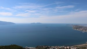
One Landscape, One Story
The Bay of Vlora changes according to where it is observed.
From Kanina, it appears as one geographical form.
From the waterfront, it becomes part of the rhythm of the city.
From a fishing boat, it is wind, depth and distance.
From Orikum, it is shelter and ancient movement.
From Sazan, it becomes the entrance to the Adriatic.
From Zvërnec, it is lagoon, forest and open sky.
Each viewpoint reveals a different bay.
None explains it alone.
Taken together, they show how physical geography became human history, and how human
activity continues to reshape the coastline.
Karaburun is no longer simply a peninsula in the distance. It becomes the natural structure
protecting the inner water.
Sazan is no longer only an island on the horizon. It becomes the point where shelter opens
towards the wider Mediterranean.
The lagoon is no longer an empty space beyond the city. It becomes a living transition between
sea and land.
Vlora itself begins to appear differently.
The city did not simply grow beside a beautiful coastline.
It grew because this coastline created the conditions for protection, movement, settlement and
connection.
The sea, the land and the people of Vlora are not separate subjects.
They are one landscape, telling the same story.


