
The Limestone Wall That Created the Bay
Some landscapes reveal their importance immediately.
Karaburun does not.
From the waterfront of Vlora, the peninsula appears as a long ridge of pale limestone
extending towards the Strait of Otranto. It forms a dramatic horizon, changing colour
with the light and seeming to complete the natural shape of the bay.
Yet its importance is not found in what it shows.
It is found in what it does.
Remove Karaburun from the landscape and the Bay of Vlora changes completely. The
protected water opens towards the Ionian Sea. Waves travelling across long distances
reach the coastline with greater force. Navigation becomes less secure. Settlement
patterns develop differently. The maritime history of the region follows another path.
Karaburun did not become important because people built upon it.
People built around it because Karaburun was already important.
When This Was Still a Sea
The cliffs of Karaburun did not begin as mountains.
They began beneath the water.
More than one hundred million years ago, during the Cretaceous Period, much of this
region formed part of a warm marine environment. Organisms with calcium-rich shells
lived and died in these waters, leaving their remains to accumulate slowly on the seabed.
Layer followed layer over immense periods of time.
Under pressure, this material became limestone.
The white cliffs rising above the Ionian Sea are therefore not simply rocks beside the
water. They are the compressed remains of an ancient marine world.
Every ridge once belonged to the seabed.
This creates one of Karaburun’s most remarkable geological reversals.
The land that protects the sea today was itself created by the sea.
Later tectonic movement gradually lifted these formations above the surface. The slow
interaction of the African and Eurasian plates folded, fractured and raised sections of
ancient seabed, helping create the mountains of southern Albania.
Standing on Karaburun today means standing on the remains of an ocean floor.
Once this is understood, the peninsula no longer appears to be a fixed wall between land
and water.
It becomes part of a much longer transformation in which the sea became stone and the
stone began shaping the sea.
The Architecture of Limestone
Karaburun’s geological story did not end when the peninsula rose above the water.
It entered another phase.
Limestone appears solid, but it is slowly altered by water. Rain absorbs carbon dioxide
from the air and soil, becoming slightly acidic. When it enters fractures in the rock, it
gradually dissolves the limestone.
Small cracks widen.
Channels develop.
Cavities grow into underground spaces.
This process, known as karstification, has shaped the peninsula for thousands of years.
It explains the fractured slopes, caves, hidden passages and irregular coastline that define
Karaburun today.
The peninsula is therefore not a static mass of stone.
It is still being transformed.
The movement is too slow to watch, but its effects are visible everywhere. Surface water
disappears into cracks. Cliffs are opened by cavities. Coastal caves expand where rock,
rain and wave energy act together.
What appears permanent is still changing.
The Mountain That Drinks the Rain
One of the most surprising features of Karaburun is the absence of permanent rivers.
Rain falls across the peninsula during the wetter months, but very little of it forms visible
streams.
On most landscapes, water collects and moves downhill across the surface.
On Karaburun, it disappears.
The explanation lies in the limestone. Water enters the fractured rock and travels through
underground channels rather than remaining above ground.
The mountain, in a sense, drinks the rain.
This single geological characteristic has influenced almost every aspect of human life on
the peninsula.
Fresh water remained limited. Agriculture was difficult. Permanent settlements were few.
Large communities could not develop easily across terrain where water was hidden
beneath the surface.
Karaburun’s isolation was therefore not created only by distance or steep slopes.
It was created by geology.
The same rock that formed the peninsula also determined how difficult it would be to live
there.
This helps explain why people often passed along Karaburun, sheltered beside it or used
parts of its coastline without transforming its interior into an urban landscape.
Geology did not simply shape the land.
It defined the limits of settlement.
The Peninsula That Changed the Sea
Karaburun does more than occupy space between the Bay of Vlora and the Ionian Sea.
It changes the behaviour of the water around it.
Waves travelling across open sea carry energy built over long distances. On an exposed
coastline, that energy reaches the shore directly, creating stronger waves, more erosion
and less predictable conditions.
Karaburun interrupts that movement.
Its long position along the western side of the bay acts as a natural barrier. Waves
approaching from the open Ionian meet the peninsula before reaching the inner coastline.
Some energy is absorbed.
Some is redirected.
Some is reduced before entering the bay.
The result is a striking contrast between the exposed western coast of Karaburun and the
more protected waters facing Vlora, Radhimë and Orikum.
A boat can travel a relatively short distance and move between two different maritime
environments.
Outside the peninsula, the sea feels open and direct.
Inside the bay, it becomes more sheltered.
The calmness associated with the Bay of Vlora is therefore not a fortunate accident of
weather.
It is produced by the shape of the land.
Karaburun is not simply the western edge of the bay.
It is part of the structure that created the bay.
A Harbour Before Harbours Existed
Before modern navigation, sailors depended on their ability to read the coastline.
Mountains, headlands and islands became points of orientation. Their outlines indicated
location, direction and the conditions that might lie ahead.
Karaburun became one of those signals.
For vessels approaching from the Ionian Sea, its limestone ridge marked the entrance
towards more protected water.
Beyond it lay the Bay of Vlora, where ships could reduce risk, wait for better weather or
prepare for the passage through the Strait of Otranto.
The peninsula functioned as maritime infrastructure long before people constructed ports,
breakwaters or navigation systems.
Its importance was understood through experience.
Sailors learned which side of the coast offered shelter, where winds changed and where a
vessel could pause before continuing.
This knowledge was not always written down.
It travelled with people.
It passed from experienced sailors to younger crews, from one journey to the next.
Ancient navigators trusted landscapes long before they trusted maps.
Karaburun was one of the landscapes they learned to trust.
Grama Bay and the Memory of Travel
Along the western coast of Karaburun, Grama Bay preserves this maritime history in an
unusually human form.
Hidden beneath steep limestone cliffs, the bay offered shelter to sailors travelling along
one of the Mediterranean’s important maritime routes.
Crews stopped there to wait for better wind, repair vessels, collect water where possible
or rest before continuing their journeys.
Many left a mark behind.
More than fifteen hundred inscriptions have been carved into the surrounding rock across
different historical periods.
Some record names.
Others contain prayers, symbols or brief signs of presence.
Most were not created as monuments.
They were simple acts performed by people who did not know whether anyone would
read them centuries later.
Together, the inscriptions transform Grama Bay into something more than a sheltered
cove.
It becomes an archive of ordinary travel.
Kings, merchants, sailors, soldiers and anonymous crews may have crossed the same
waters for very different reasons, but they shared the need for protection.
The rock that sheltered them also preserved their presence.
Grama Bay can therefore be understood as one of the Mediterranean’s oldest surviving
guest books.
Its inscriptions remind us that journeys have never been only about movement.
They have also been about the need to leave behind evidence that someone passed
through.
A Landscape That Resisted Cities
Many Mediterranean coastlines have been transformed repeatedly by settlement,
agriculture and construction.
Karaburun followed a different path.
Its steep slopes, limited water and fractured limestone made permanent development
difficult. There was little level ground for extensive agriculture and few reliable
freshwater sources capable of supporting large communities.
People used the peninsula.
They navigated around it, sheltered beside it, grazed animals in certain areas and
occupied strategic positions.
But they rarely transformed it into a continuous inhabited landscape.
This resistance to settlement preserved something increasingly uncommon along the
Mediterranean coast: a peninsula whose character is still largely determined by geology,
wind, vegetation and the sea.
Karaburun did not exist outside history.
It experienced military use, navigation, fishing and human movement across many
centuries.
Its difference lies in the fact that history did not completely cover the natural structure
beneath it.
The landscape remained stronger than the settlements attempting to occupy it.
Life Adapted to Stone
Karaburun can appear dry, exposed and inhospitable, especially during summer.
Yet the peninsula supports an ecosystem shaped by long adaptation to difficult
conditions.
Plants growing here must survive intense sunlight, limited soil, salt carried by the wind
and long periods without rain.
Mediterranean shrubs, aromatic herbs and resilient trees have developed ways to
conserve water and reduce exposure.
Small leaves limit moisture loss.
Deep roots search for water inside fractured ground.
Some plants slow their growth during the hottest months and become active again when
cooler, wetter conditions return.
Spring briefly transforms the peninsula.
Flowers appear across slopes that seemed almost empty during summer. New growth
follows winter rain, filling the landscape with colour before heat and drought return.
This rhythm is not a sign of weakness.
It is the strategy that allows life to continue.
Nothing grows on Karaburun by accident.
Every plant represents a successful response to stone, wind and scarcity.
The Forest Beneath the Sea
Some of Karaburun’s most important habitats cannot be seen from land.
They grow beneath the water.
Meadows of Posidonia oceanica form underwater landscapes along parts of the coastline.
Although it resembles seaweed, Posidonia is a flowering marine plant found only in the
Mediterranean.
Its meadows provide shelter, nursery areas and feeding habitat for many marine
organisms.
They also help stabilise sediment close to the seabed. Their leaves slow water movement,
while roots and underground structures hold material in place.
This contributes to the clarity associated with parts of the Karaburun coastline.
The absence of major rivers means that relatively little sediment is carried directly from
the peninsula into the sea. Where healthy seagrass meadows remain, they help prevent
loose material from being repeatedly lifted into the water.
The relationship is subtle but important.
Clear water allows sunlight to reach the meadow.
The meadow helps maintain conditions in which light can continue to pass through the
water.
The forest supporting these transparent seas grows beneath the surface.
What appears from a boat as a dark patch below the blue is not an imperfection in the
view.
It is part of the system creating it.
A Peninsula Made of Relationships
Karaburun cannot be understood through one feature alone.
Its limestone explains the absence of rivers.
The lack of water helps explain the scarcity of permanent settlements.
Limited development helps preserve natural habitats.
The peninsula’s shape changes wave movement.
Sheltered water influences navigation, fishing and the development of the Bay of Vlora.
Each element helps explain the next.
Karaburun is not simply a collection of cliffs, caves, beaches and underwater habitats.
It is a connected system.
The stone shapes the water.
The water shapes the coast.
The coast shapes how people move.
Human history follows the conditions created by the landscape.
This is why the peninsula is more than beautiful.
It is functional.
Why Karaburun Matters
Understanding Karaburun changes the way the entire Bay of Vlora is seen.
The peninsula is no longer a backdrop on the western horizon.
It becomes the natural structure protecting the water inside the bay.
Its geology explains its shape.
Its shape explains the calmness of the sea.
The sea explains navigation.
Navigation helps explain settlement, trade and history.
Remove Karaburun from this chain and the Bay of Vlora becomes a different place.
Its protected water, maritime routes, coastal settlements and historical importance would
all have developed under different conditions.
The peninsula never needed to become famous in order to matter.
Its importance was decided long before people arrived.
Seeing Karaburun Differently
After understanding the forces that shaped the peninsula, its familiar outline begins to
change.
The pale cliffs become the remains of an ancient seabed.
The absence of rivers becomes evidence of a hidden underground system.
A dark patch beneath the water becomes a living meadow.
An isolated cove becomes part of a maritime route travelled for centuries.
Even the calm water of the Bay of Vlora acquires another meaning.
It is no longer simply a beautiful condition.
It is the result of a limestone wall standing between the bay and the open Ionian Sea.
Knowledge should not reduce the power of the landscape.
It should make that power visible.
Karaburun appears still because its transformations happen across geological time.
It appears empty because much of its life is hidden beneath stone or water.
It appears distant because most people experience it only from the opposite shore.
Yet the peninsula is constantly present in the life of the bay.
It shapes the wind, the waves, the horizon and the history of the communities living
beside it.
Karaburun is not simply part of the view from Vlora.
It is one of the reasons that view exists.
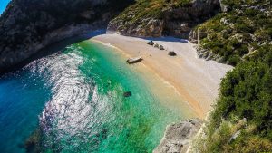
Experience Karaburun and the Bay of Vlora
The Bay of Vlora is best experienced, not simply visited.
Valza Boutique Hotel offers travellers a natural starting point from which to explore
Karaburun, the coastline and the maritime landscapes documented throughout the
MAREOGRAPH series.
From the hotel, the peninsula’s long outline remains visible across the bay, changing with
the light while continuing to define the western horizon.
Above the hotel, Eden by Valza continues that relationship through Mediterranean
cuisine inspired by local ingredients, seasonal rhythms and the same sea shaped by
Karaburun’s presence.
About MAREOGRAPH
MAREOGRAPH is an independent editorial project created by Valza Boutique Hotel to
document and explain the natural, historical and cultural heritage of the Bay of Vlora and
the Albanian Mediterranean.
Each Knowledge Unit combines scientific research, historical context, local knowledge
and human storytelling to build a long-term digital library about the landscapes,
ecosystems, traditions and communities that define this coastline.
MAREOGRAPH does not seek to replace the experience of visiting Karaburun or the
Bay of Vlora.
Its purpose is to make that experience richer by helping readers understand what they are
seeing, how the landscape was formed, why it matters and what should be protected as
the coastline continues to change.


