
The Island That Was Closed to the Sea
From almost every open viewpoint across the Bay of Vlora, Sazan is there.
It lies low along the horizon, close to the point where the Adriatic opens towards the Ionian Sea.
Boats pass in front of it. Maritime routes curve beside it. From the city, the island can seem
familiar simply because it is always visible.
For most of its recent history, however, visibility did not mean access.
Sazan could be seen, but not freely entered.
This contradiction defines the island more clearly than its size, its abandoned buildings or its
military remains. Sazan was shaped not only by what existed on it, but by what was kept away
from it.
Its position created strategic value. Strategic value produced control. Control produced isolation.
Isolation, over time, preserved parts of the landscape that might otherwise have disappeared.
To understand Sazan is therefore to understand how geography can determine the life of a place
long before that place chooses its own future.
Where Two Seas Change Character
Sazan stands close to one of the Mediterranean’s most important maritime thresholds.
To the north lies the Adriatic Sea, shallower and more enclosed. To the south, the Ionian
becomes deeper, more exposed and increasingly connected with the wider Mediterranean.
Between them, the Strait of Otranto forms the passage through which water, currents and vessels
move.
Sazan occupies this transition directly.
The island does not simply stand between two named seas on a map. It stands where the physical
character of the marine environment begins to change.
Water masses move through the strait at different depths. Weather arriving from the open Ionian
meets the entrance of the Adriatic. Maritime routes naturally concentrate within the same
corridor.
Any vessel entering or leaving the Adriatic passes within reach of this geography.
This gives Sazan a significance greater than its physical size.
The island is small compared with the seas surrounding it, but it stands where movement
becomes difficult to avoid.
Seen from Vlora, Sazan marks the horizon.
Seen from the sea, it marks a threshold.
An Island That Belongs to Karaburun
Although Sazan appears separate, geologically it is not an isolated object.
The island belongs to the same broader limestone system as the Karaburun Peninsula opposite it.
Both were shaped through geological processes that lifted ancient marine formations above the
surface. Their fractured rock, limited soil and dry terrain reveal a shared origin.
The sea now separates them.
Geology still connects them.
This relationship changes the way the entrance to the Bay of Vlora can be read.
Karaburun forms the long western wall of the bay. Sazan stands near the opening. Together, they
create a natural gateway between sheltered inner water and the wider marine corridor beyond.
Sazan’s terrain reflects the same geological limitations seen across Karaburun.
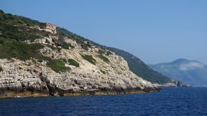
The island has rocky slopes, thin soils and very limited freshwater. It has no landscape capable of
easily supporting extensive agriculture or the gradual growth of a large civilian settlement.
These conditions were not secondary inconveniences.
They helped determine what the island could become.
Sazan was never naturally suited to continuous urban expansion.
It was suited to observation, defence and position.
Geography Created the Opportunity
Geography does not automatically create history.
It creates possibilities.
Sazan’s position near the entrance to the Adriatic offered a clear view over maritime movement.
From elevated parts of the island, vessels approaching the strait or leaving it could be observed
across a wide area.
This was not only a symbolic advantage.
It was practical.
An island placed away from the mainland could be controlled more easily. Its surrounding water
created distance. Its height offered visibility. Its location allowed coastal and maritime activity to
be monitored.
During the twentieth century, especially during the Cold War, this geographical opportunity was
transformed into military infrastructure.
The island was not organised primarily as a civilian community.
It was organised as a system of observation, defence and restricted movement.
Bunkers were built into the terrain.
Underground passages connected strategic points.
Elevated positions were adapted for monitoring the surrounding sea.
Access was regulated because the island’s usefulness depended partly on controlling who could
approach it and what could be seen from it.
Sazan’s military history did not begin with the construction of bunkers.
It began with the shape of the map.
The buildings came later.
An Island Built for Control
The military infrastructure of Sazan can appear scattered when encountered today.
An abandoned building stands among vegetation. A bunker opens towards the coast. A tunnel
disappears into the rock. Roads lead towards positions that no longer serve an obvious purpose.
Originally, these elements belonged to one connected system.
Buildings supported personnel.
Tunnels allowed protected movement.
Observation points faced the sea.
Defensive positions responded to the coastline and the direction of possible approach.
The island functioned less like a settlement and more like an instrument.
Its purpose was not simply to house people.
Its purpose was to extend control across the surrounding water.
This distinction helps explain why the built landscape feels different from that of an ordinary
village or town.
Civilian settlements usually grow gradually. Homes, workshops, public spaces and roads
accumulate according to daily needs.
Sazan developed according to strategic logic.
Infrastructure appeared where function required it.
Movement was organised around security rather than convenience.
Even the island’s isolation became part of that system.
Isolation Was Not Emptiness
For decades, Sazan operated under restricted access.
Entry was limited. Movement was monitored. The island remained separate from the normal
rhythm of coastal life developing across the rest of the Mediterranean.
This isolation should not be confused with inactivity.
Sazan was not empty.
It was controlled.
People lived and worked there within a closed structure shaped by military purpose. Daily life
existed, but it existed under rules defined by the island’s strategic role.
The sea surrounding Sazan created a physical boundary.
Authority turned that boundary into a social one.
From Vlora, the island was visible enough to feel close. In reality, it belonged to another world.
The distance was measured not only in kilometres.
It was measured in permission.
The Human Life Behind the Military Landscape
The remains of Sazan are often described through bunkers, tunnels and abandoned buildings.
Behind those structures were people.
Personnel lived for long periods on an island separated from ordinary civilian life. Supplies had
to arrive by sea. Weather influenced movement. The horizon was always present, yet leaving the
island was not simply a personal decision.
This creates another layer within Sazan’s story.
The island was designed around surveillance, but it was also experienced through routine.
Someone maintained the roads.
Someone waited for supplies.
Someone watched changing weather above Karaburun.
Someone entered the same tunnel every day without imagining that, decades later, visitors would
walk through it as a historical remnant.
Military infrastructure can make a landscape feel impersonal.
Human life made it ordinary from within.
For those stationed there, the island was not only a strategic point between two seas.
It was where mornings began, where work was performed and where distance from the mainland
became part of daily existence.
The structures remain.
Most of those routines have disappeared.
A Landscape Separated from the Mediterranean
While many Mediterranean coastlines changed through tourism, construction and expanding
settlement, Sazan followed a different path.
Its development remained limited to the needs of control.
There were no resorts spreading gradually along the coast. There was no continuous civilian
building. Agriculture did not reshape large areas of the terrain.
The island did not evolve alongside the destinations visible across the wider region.
It was deliberately separated from them.
This had an unexpected environmental consequence.
Military use altered parts of Sazan, but restricted civilian access also limited many of the
pressures that transformed other Mediterranean islands and coastlines.
Vegetation continued to follow patterns shaped largely by terrain, climate and abandonment.
Coastal areas avoided the constant expansion of roads, hotels and recreational facilities.
Natural processes continued around infrastructure that had been built for a completely different
purpose.
Sazan was not protected because it was intended to become an ecological sanctuary.
It was partly preserved because people were kept away.
Isolation became an accidental form of conservation.
When Restriction Preserves
This is one of the central paradoxes of Sazan.
The same system that made the island inaccessible also helped preserve some of its natural
character.
Control prevented ordinary access.
The absence of ordinary access reduced development.
Reduced development allowed parts of the landscape to remain less disturbed.
The process was not planned as environmental policy.
Its outcome was nevertheless environmental.
This does not mean that military activity had no impact. Construction, infrastructure and
occupation altered the island in visible ways.
It means that Sazan avoided another type of transformation: the gradual replacement of natural
coastline by continuous civilian development.
The island preserved both nature and history in an unusual combination.
Vegetation grows around abandoned structures.
Roots enter cracks in buildings.
Paths disappear beneath plants.
Bunkers remain in positions where the surrounding landscape has begun to reclaim them.
Nature has not erased the military past.
It has begun to absorb it.
The Island After Opening
As Sazan became more accessible, its meaning began to change.
The island was no longer only a closed military zone.
It became a landscape that could be approached, explored and interpreted.
Visitors generally arrive by sea, repeating the movement that has always defined the island.
There is no gradual road approach or urban entrance. The coastline appears first, followed by
abandoned structures and the traces of a system that once depended on secrecy.
This creates an unusual experience.
Sazan is not entirely natural.
It is not entirely historical.
It is not yet a conventional tourism destination.
It exists between these identities.
A visitor encounters military remains without the active system that once connected them.
Buildings survive without their former routines. Tunnels remain, but the authority that controlled
access has disappeared.
The island has opened physically faster than it has developed a new identity.
It is accessible.
It is still being understood.
The Landscape of Abandonment
Abandonment is often described as emptiness.
On Sazan, it functions more like a second period of transformation.
When buildings lose their purpose, the environment begins working upon them.
Salt enters concrete.
Moisture damages interiors.
Vegetation covers roads and walls.
Openings once used for observation become frames for sea and sky.
The military landscape gradually becomes part of the natural one.
This process gives Sazan its distinctive atmosphere.
The island does not present history through carefully restored monuments.
It presents history through remains.
A bunker may still face the same maritime corridor it was designed to monitor, but it no longer
controls anything.
A tunnel may preserve the logic of protected movement, but now leads visitors rather than
personnel.
The purpose has disappeared.
The position remains.
This is why Sazan can feel both abandoned and intensely present.
Its buildings are no longer active, yet they continue explaining why the island mattered.
A System Defined by Position
Sazan’s history follows a clear sequence.
Its geological origin created the island’s form.
Its form created physical limitations.
Its position created strategic value.
Strategic value produced military control.
Control produced isolation.
Isolation helped preserve parts of the landscape.
Opening the island revealed all these layers at once.
Each stage follows from the one before it.
This is what makes Sazan more than an island containing military ruins.
It is a place where geography can be seen shaping decisions across time.
The island was not transformed because it offered abundant resources, fertile soil or easy
settlement.
It was transformed because it occupied the right point in the sea.
Its greatest resource was location.
A Threshold Seen from Both Sides
From the Bay of Vlora, Sazan often appears to close the horizon.
In reality, it marks an opening.
Behind the island lies the Strait of Otranto and the route towards the wider Mediterranean.
Inside it lie the more protected waters of the bay.
Sazan therefore belongs to two landscapes at once.
It is part of the Bay of Vlora, yet it also stands at the edge of something much larger.
This dual role explains its strategic history.
The island could look inward towards the bay and outward towards maritime movement through
the strait.
It stood near shelter while observing exposure.
It belonged to Albania’s coast while facing routes connecting different shores.
Sazan does not simply separate two seas.
It makes their connection visible.
Why Sazan Matters
Sazan matters because it reveals how directly geography can shape history.
Its position influenced military decisions.
Those decisions created decades of controlled access.
Controlled access produced isolation.
Isolation preserved parts of the landscape that might otherwise have been transformed.
Few places show this chain so clearly.
The island is not important because of one bunker, one tunnel or one historical period.
It is important because all these elements were produced by the same geographical fact.
Sazan stands where movement between two maritime worlds becomes concentrated.
Everything else followed.
Understanding this changes the way the island is seen from Vlora.
It is no longer simply a low shape on the horizon.
It becomes the point where the protected bay opens towards the Strait of Otranto.
It becomes a geological relative of Karaburun.
It becomes a former instrument of surveillance and a landscape now being reclaimed by nature.
It becomes evidence that a small place can hold great strategic importance when it occupies the
correct position.
Seeing Sazan Differently
After understanding the forces that shaped Sazan, the familiar outline begins to change.
The rocky slopes become part of the same geological system as Karaburun.
The absence of large settlements becomes the result of limited water, difficult terrain and long
restriction.
The abandoned infrastructure becomes evidence of a system built to observe the sea.
The vegetation surrounding it becomes a sign of what happened after control ended.
Even the island’s silence acquires another meaning.
It is not the silence of a place without history.
It is the silence that followed a period when almost everything was monitored.
Sazan appears isolated because it was made isolated.
It appears preserved because restriction limited transformation.
It appears unfinished because the island has left one identity without yet fully entering another.
Knowledge should not remove the mystery of Sazan.
It should reveal where that mystery came from.
The island was closed because its position mattered.
Now that it is open, the greater responsibility is to understand what should happen next.
Experience Sazan and the Bay of Vlora
The Bay of Vlora is best experienced, not simply visited.
Valza Boutique Hotel offers travellers a natural starting point from which to explore Sazan,
Karaburun and the maritime landscapes documented throughout the MAREOGRAPH series.
From the hotel, Sazan remains visible near the entrance of the bay, changing with the light while
continuing to mark the threshold between the Adriatic and Ionian seas.
Above the hotel, Eden by Valza continues that relationship through Mediterranean cuisine
inspired by local ingredients, seasonal rhythms and the same coastline shaped by the movement
of water and people.
About MAREOGRAPH
MAREOGRAPH is an independent editorial project created by Valza Boutique Hotel to
document and explain the natural, historical and cultural heritage of the Bay of Vlora and the
Albanian Mediterranean.
Each Knowledge Unit combines scientific research, historical context, local knowledge and
human storytelling to build a long-term digital library about the landscapes, ecosystems,
traditions and communities that define this coastline.
MAREOGRAPH does not seek to replace the experience of visiting Sazan or the Bay of Vlora.
Its purpose is to make that experience richer by helping readers understand what they are seeing,
how the landscape was formed, why it matters and what should be protected as the coastline
continues to change.


